Statewide Shoreline Monitoring Framework

 In 2019, the Science and Resilience Institute led an interdisciplinary team of local stakeholders, technical experts, agency staff, and other partners to develop and pilot a standardized framework to monitor shoreline features across all coastal regions of New York State. 

IMG_20190712_121721-3

Background

 Storm hazards and changing water levels are pushing coastal communities and decision makers in NYS to consider innovative approaches to coastal protection. Natural and nature-based features (NNBF), also known as living shorelines, are an increasingly popular alternative to conventional shoreline armoring. NNBF are thought to mitigate some flooding and erosion, while also providing ecological and social co-benefits without disrupting natural coastal processes.

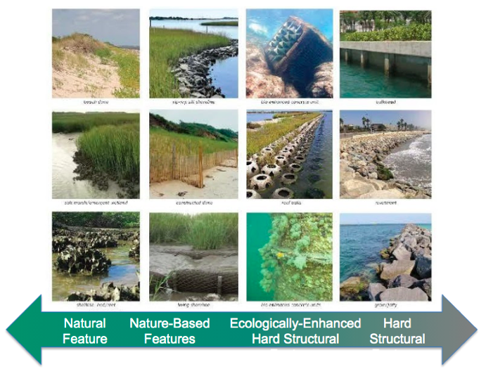
However, decision-makers need data to show whether NNBF will achieve the resilience benefits that communities value. This data gap motivated a collaborative multi-year, stakeholder-driven effort led by the Science and Resilience Institute, and funded by NYSDOS, NOAA, and NYSERDA. The result is a Statewide Shoreline Monitoring Framework that guides consistent data collection and evaluation. Using the framework, managers and communities will be able to evaluate resilience benefits across shoreline types to make evidence-based decisions about coastal protection.

Use the Framework to Monitor a Shoreline

Shoreline stewards, researchers, students and others can join the effort to collect comparable data across diverse shoreline types and geographies of NYS. There are 17 indicators with protocols and field worksheets (available by request from DOS) that are designed to guide data collection that is robust yet achievable, even with limited resources or capacity.

Indicators are categorized within three resilience service areas: 

  • Ecological function
  • Structural integrity & hazard mitigation
  • Social and economic outcomes
Ecological Function
Structural Integrity + Hazard Mitigation
Social and Economic Outcomes

Location and Feature Types

This framework is meant for any and all tidally influenced shorelines, with a focus on the following areas:

  • Long Island
  • New York Harbor
  • Hudson Valley
  • the Great Lakes

The framework applicable to the full spectrum of shoreline types:  

What's Next

Near-Term
  • Grow network of monitoring partners who will use the framework at local shorelines.
  • Collect and analyze data sets in a common database.
  • Refine the framework and protocols based on end-user feedback.
Long-Term
  • Assess trends in performance and benefits.
  • Improve evidence-based shoreline decision making in NYS

Project Sponsors

Project Partners

  • NY Sea Grant 
  • Consensus Building Institute
  • SCAPE 
  • Arcadis 
  • NYC Parks 
  • NYS DEC Hudson River Estuary Program 
  • CUNY Advanced Science Research Center / Brooklyn College
  • US Forest Service, NYC Urban Field Station 
  • NY-NJ Harbor Estuary Program